Dry through Thursday; Strong to severe storms possible late tonight

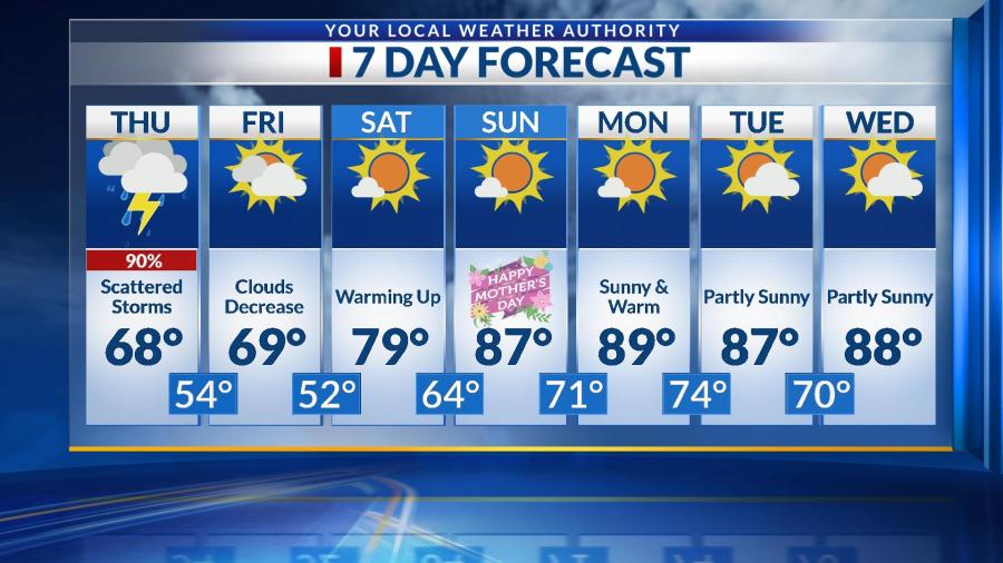
Thursday will see sunshine, calm winds and high temperatures in the lower to middle 80s. Clouds will increase overnight, and storms are likely to move through the Four States after 3 AM Friday. These storms will hold a wind, hail and flooding threat through about 8 AM, and there will likely be enough lightning and thunder to wake you up a little early tomorrow. Make sure to stay weather aware and monitor this risk through your Friday morning commute. Rainfall totals could be close to 3 inches in some areas.

Clouds will slowly decrease through Friday afternoon as we warm into the lower 80s after a stormy start to the day. We’ll see a lot of sunshine and no chances for rain through the weekend and into next week. Those temperatures will warm well into the 90s through this time period.

Severe storms likely Sunday afternoon and evening

Clouds are expected to increase through your Saturday night as temperatures cool into the middle 60s. Temperatures on Sunday should quickly warm into the lower 80s before storms take over the forecast. Between Noon & 8 PM Sunday, storms will likely pop up, and they will have plenty of energy to produce 60+ MPH winds and 1+” diameter hail. Localized heavy downpours are also possible during this time period. While the tornado threat is virtually zero, note that these storms can still create a lot of damage. Make sure to stay weather aware through Sunday afternoon and evening.

Behind this storm system, temperatures will fall into the 70s on Monday with less humid air. Isolated storms become possible again into Tuesday, and we’ll have to monitor a few more chances through the 7-day forecast. Note that there will be plenty of dry time and temperatures in the 80s, but we’re in a weather pattern right now that supports many chances for pop-up thunderstorms. Stay tuned!

Thunderstorms return for Friday; Less humid on Saturday

The chance for scattered showers and storms will stick with the Four States all day long, but there will be plenty of dry time–especially during the late morning and early afternoon. By the time the second round of storms rolls around, we’ll see a high temperatures in the middle 80s. The best chance for strong to severe storms is between 4 – 11 PM with wind and hail being the primary threats. Localized heavy rain is possible, but that threat should stay mainly to our east as we’ll likely see about a half inch of rainfall.

Skies will clear into tomorrow with less humid air as we warm into the middle 80s for Saturday. Clouds will increase again into Sunday ahead of another chance for storms Sunday afternoon. These storms could also pose a wind and hail threat. Monday looks to be dry and cooler with highs in the lower 80s before a few more chances for isolated to scattered storms into the middle of next week.

Storms continue on and off through Thursday

Over 4 inches of rain fell over parts of the Four States last night. Many flood warnings are in effect through at least Thursday morning, so use an abundance of caution during your commute. If you come across a flooded roadway, do not attempt to pass it. Widespread rain will come to an end mid-morning, but we all still have a chance to see isolated showers and storms this afternoon, as we warm into the upper 60s. Rain chances will even follow us into tonight before we dry out by Friday morning with a low in the middle 50s.

Clouds will slowly decrease through a cooler Friday, but once the sun returns this weekend, temperatures will jump well above average. We’ll warm into the upper 70s on Saturday before soaring into the upper 80s on Mother’s Day. Some of us could even hit 90 degrees early next week with plenty of sunshine and no rain chances at this time.

Scattered storms through Monday; SEVERE threat this evening & tonight

Monday will begin with scattered showers and storms, and those will stick with us through the early afternoon with little dry time. We should be cloudy & mostly dry this afternoon as we warm to near 70 with wind gusts up to 25 MPH. By 6 PM, severe storms will begin to fire up near Wichita. Between 6 PM and midnight, all of the Four States will need to monitor a wind, hail, flood & even tornado threat. The highest tornado threat will stretch from Vinita to Coffeyville to Parsons, but everyone need to stay weather aware late today and tonight. The timing for Joplin & the metro looks to be from 8 – 11 PM. Most of us are under an ENHANCED risk for severe weather for this event.

Storms will be long gone before sunrise on Tuesday, where we’ll be mostly cloudy, cooler and dry. Storms return early Wednesday afternoon ahead of another chance for strong to severe storms into early Thursday morning. This event does not look to be as intense as tonight’s could be, but we will still need to stay weather aware as we are in a very active weather pattern. Rainfall totals could range between 3-4″ for some of us (mainly south) once all is said and done this week. We’ll dry out into Friday and warm up quite a bit through a mostly dry Mother’s Day weekend.

Mostly dry for Friday; Severe threat still on for Friday night

After some morning storms mainly to our north, Friday will remain dry with some sunshine and wind gusts up to 35-40 MPH. As we close in on midnight, strong to severe storms will form near Wichita and move eastward through the night. The storms will likely weaken by the time they make it towards I-49, but a windy & hail threat will still exist. Those in SE Kansas under an enhanced risk will have to monitor hail, wind & even a tornado threat between 10 PM – 2 AM. Storms will move out of the Four States by 4 AM.

This weekend will actually be dry with mostly sunny skies and temperatures in the 70s. Storms will move back into the area early Monday morning and stick with us on and off through next week. Models indicate that some storms on Monday and Wednesday could potentially be strong to severe. Temperatures will fall into the upper 60s late next week.

Scattered storms today; Severe potential for late Friday

Rain chances return today, with isolated to scattered storms possible through the morning and early afternoon hours. We do still have a chance for rain later this afternoon and evening, but it will mainly stay to the north. Non-severe storms are also possible into early Friday morning before most of tomorrow will be dry. Friday will see some sunshine and warmer temperatures before a severe threat approaches us into the overnight hours.

The strongest storms Friday night will stay to our west, as these will likely lose some energy before they make their way to the I-49 corridor. Still, everyone in the Four States has a hail, wind & tornado threat, with the highest staying west–over parts of Southeast Kansas closer to Wichita. Rain could linger into early Saturday morning before we dry out and see a good amount of sunshine and dry time this weekend.

Storms will move back into the Four States late Sunday night into early next week. Temperatures during the entire 7-day forecast should remain in the 70s, and we’ll still see plenty of dry time, even with all of these rain chances.

Becoming breezy Wednesday; Rain returns early Thursday morning

Wednesday will see wind gusts out of the south up to 30 MPH with mostly sunny skies and temperatures warming into the middle 70s. This evening, clouds will increase, and rain chances return after midnight. Most will not see rainfall until closer to sunrise Thursday morning, and a few rumbles of thunder and a quick heavy downpour are both possible. Rain should be done before tomorrow afternoon, and we’ll be mostly dry from then until late Friday.

Severe weather is possible Friday evening – night for the Four States. The Storm Prediction Center has put us under an enhanced and slight risk for severe weather during this time, where ALL modes of severe weather are possible. We’ll have more details on the exact timing & threats very soon, so stay updated with the latest forecast.

Saturday could see some rain early, but most of this weekend is actually trending drier. Rain will pick up again Sunday night into next week, and we’ll be monitoring more rain chances into the first few days of May.

Windy Wednesday; Strong storms possible this evening

Wednesday will be cloudy and windy, with gusts up to 40-45 MPH possible. Spotty showers are possible through the day, but the majority of today should stay dry. This evening, after the sun sets, a boundary will stall over the Four States, allowing for storms to ignite. If they do, they could create strong winds and small hail. This threat will last into Thursday morning. Temperatures will remain in the 60s today and tonight.

We’ll completely dry out Thursday afternoon as we warm into the upper 70s. Friday and Saturday will be dry with highs in the upper 70s and lower 80s. By Saturday night, rain chances increase again and will stick with us through Sunday and even into early Monday. We’ll be tracking a widespread and potentially heavy rain event that could lead to a few inches of rainfall during that time. This will also drop temperatures below average to begin next week. We’ll keep you updated.

Strong to severe storms likely along and south of I-44 early Wednesday

FORECAST UPDATE AS OF 4 AM WEDNESDAY: Strong to severe storms are expected to fire up after 5 AM mainly along and south of I-44, and they will stick with us through lunchtime today. The biggest threats are for strong winds and large hail, but a tornado or two cannot be ruled out during this time. Make sure to follow along through social media and on-air through the morning commute with updates. We likely won’t be completely dry until after noon.

Temperatures will fall into the 50s this afternoon, and we could even see some sunshine before it sets tonight. We’ll cool into the middle 30s overnight, and since we’re also expecting clear skies and calm winds, some areas could see some frost–especially northwest of I-44. We’re monitoring a few more chances for rain showers into this weekend, but most of it should stay south until Saturday night. A few showers are possible on and off through Easter Sunday with temperatures cooling into the 60s. We’ll have more details on timing, locations and totals by the end of this week.