Warm and breezy Sunday; Strong to severe storms possible Sunday night

Winds will pick up into Sunday morning, gusting up to 35 MPH out of the south and warming us into the upper 70s in the afternoon. Clouds will also increase ahead of the chance for strong to severe storms late Sunday night. Storms are possible after 9-10 PM Sunday night and could last into midday Monday. All modes of severe weather are possible, but the strongest storms look to stay to our west.

We’ll be mostly dry through a cooler Monday afternoon, but temperatures will warm into the 80s on Tuesday. Spotty convection is possible Tuesday afternoon, but the best chance for widespread storms looks to be Tuesday night into Wednesday morning. This storm system could potentially be bigger than Sunday night’s again where all modes of severe weather are possible. Make sure to have ways to get and hear alerts at night for Sunday night and Tuesday night.

Thursday will be sunny, dry and a little breezy as temperatures only warm into the 60s. Friday has a rain chance late that could last into early Saturday. Temperatures are expected to be below average through Easter weekend.

What's a frost quake? Listen to one in Kansas

CONCORDIA (KSNT) – A couple in Kansas said they recently witnessed a winter weather phenomenon known by several names: cryoseisms, frost quakes or ice quakes.

Melody Gillan, who recently moved to Concordia with her husband, explained what she discovered.

“I was outside one day and kept hearing these ‘pops’ that sounded like firecrackers going off underground, right by where I was standing,” Gillan said. “My husband thought I was crazy. He said it was someone shooting a gun off in the distance.”

Gillan filmed the popping noises as they happened again Tuesday.

“A few days later I was outside and he finally decided I wasn’t crazy, there was something popping in the yard under the ground,” Gillan said. “My husband was born here in Concordia and lived here 37 years, and we have friends here and none have ever heard of frost quakes.” 

KSNT’s StormTrack Weather Team created this graphic to help explain the process that causes frost quakes. When temperatures fall rapidly, it causes underground water to quickly freeze. This newly frozen ice expands and puts extra pressure on the soil and bedrock around it.

Once the pressure builds enough, it can make the soil and even bedrock lower underground crack. As a result, the cracking can cause loud booms and sometimes even shaking.

The Encyclopedia Brittanica reports frost quakes can sometimes be mistaken for true earthquakes because of how intense the seismic vibrations can get, and they’re more common in polar and mountainous regions where glaciers move. However, because Gillan and her husband did not report any shaking, the StormTrack Weather Team believes the frost quakes they experienced were caused by pressure cracks in the soil, not the bedrock lower underground.

Visit KSNT’s Share It section to submit videos of frost quakes around Northeast Kansas, or go to the StormTrack Weather page for the latest forecasts and interactive radar.

Windy today, storms tonight and wintry weather tomorrow

Wednesday will be warm, cloudy & windy with gusts up to 45 MPH for all of us in a Wind Advisory. Rain will form later this afternoon, but most will stay dry until late tonight. Storms will develop close to midnight, and heavy rain, strong winds, frequent lightning and small hail are possible. The SPC has parts of NE Oklahoma in a slight risk for tonight, but the tornado threat should remain to our south. Rainfall totals will be between 1-2″ with locally higher amounts over SW Missouri where an Areal Flood Watch is in effect.

A wintry mix will form into tomorrow morning as temperatures fall below freezing. Higher ice and snow totals will remain along and north of Pittsburg, but all of us will likely only see a couple inches of snow and light ice accumulations. Still, this could create issues on the roadways Thursday.

Abundant sunshine will lead us into a warming trend this weekend. Enjoy it while it’s here, because rain chances are growing as we enter early next week.

Snow plow drivers are the unsung heroes when winter weather hits

JOPLIN, Mo. — Most of us don’t pay much attention to what they do the rest of the year, but we sure are happy to see them when ice and snow starts falling.

If you thought you had to get up earlier than usual to get to work, don’t complain to Keith Mohlfeld.

“Tell me what time you came to work today,” said Stuart Price, Reporting.

“4 o’clock this morning,” said Keith Mohlfeld, Driver, Joplin Special Road District.

Mohlfeld is one of 10 drivers that maintain nearly 325 miles worth of roads outside of Joplin in both Newton and Jasper counties all year round.

“12 hours on, 12 hours off,” said Mohlfeld.

But this time of year, the focus is on clearing and treating the roads and it’s all hands on deck, even administrators and the office manager get behind the wheel until the job is done.

“It’s something different every day. Not sitting behind a desk, you get to go out and enjoy the scenery.”

“How important is it to be you today?” asked Price.

“I would guess pretty important. I would imagine, people still need to get to the doctor, get to work, get to the store,” answered Mohlfeld.

“And if you’re a first responder?” asked Price.

“Yeah, ambulance, fire trucks, all have to get through, police,” said Mohlfeld.

The job that these drivers for the Joplin Special Road District, the City of Joplin, and the Missouri of Transportation do is inherently dangerous on days like today, and sometimes we’re the ones making it even worse.

Mohlfield says motorists can make his job much more hazardous. He says some drivers tailgate his truck and in some cases try to pass his truck while he’s trying to make the road safer to drive for them. And he says they can end up in an accident or get stuck just like anyone else.

“Even though we’re in a big dump truck we can still get stuck, we still slide, we still can’t stop on the ice,” added Mohlfeld.

Snow lingers this morning; One last round of snow tonight

A few inches of snow fell across the Four States overnight, but it is impossible to accurately measure exactly how much because of the wind blowing it everywhere. We’ll see a good amount of dry time through the late morning and early afternoon hours before the last round of snow picks up this evening. This batch of snow will be light, likely only adding an inch or two to our totals–a little bit more is possible overnight to our southeast. Clouds will start to clear as we enter into Friday with single digit lows and wind chills well below zero. Winds will begin to calm overnight as we enter into a period of calm weather. Temperatures will begin to warm into the upper 30s and lower 40s this weekend before nearing 50 by the middle of next week.

MoDOT preparing for winter storm

MISSOURI — With winter weather on its way, MoDOT is preparing early.

People, equipment and resources are being prepared to deal with the potential for both snow and ice over the coming days.

As soon as Wednesday night, temperatures may fall to the mid-teens, which could render road salt ineffective.

“If you do find yourself stranded, I think you’re best to stay with your vehicle,” said Steve Campbell, MoDOT Southwest District Engineer. “Somebody will be around at some point. Fill up your gas tanks, have everything in your car you need to, but I think the number one thing people can do to help us is if you don’t need to drive, stay home.”

If you do need to travel, Campbell says to check road conditions before you head out. You can do so with MoDOT’s traveler information map here.

Winter Storm Warning brings ice this morning, snow through tomorrow

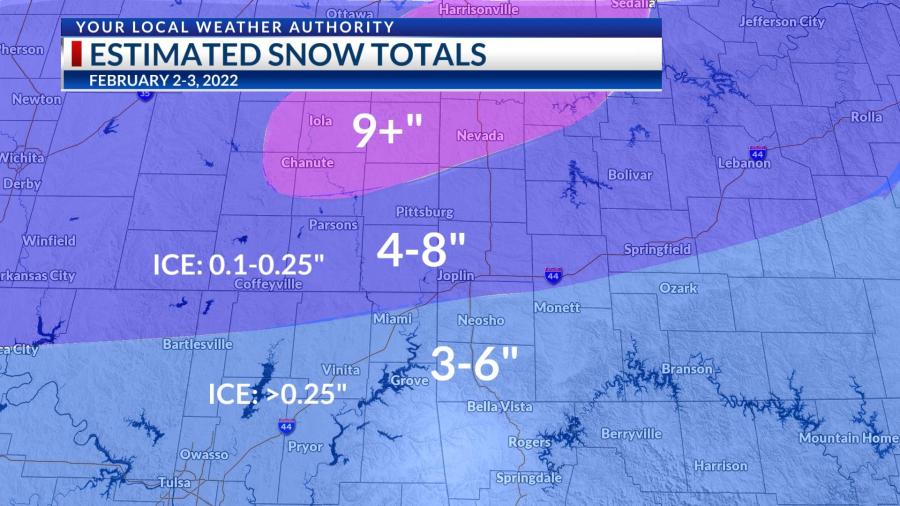
A wintry mix will persist through the mid-morning hours for most of us. Areas up near Nevada, Fort Scott & Chanute are already seeing snow–so those accumulations will be higher through this event. We should be mostly dry through the midday hours Wednesday before the second wave of precipitation starts later this afternoon. That one will see mostly snow through the Four States, only a wintry mix persist near the Missouri-Arkansas border. Everyone will see snow after midnight tonight, and it will be heavy at times. It is likely that we’ll go to bed with a dusting on the ground and wake up to several inches of snow tomorrow morning. Accumulations will likely be 4-8″ with higher amounts to the north and lower amounts to the south. We’ll be dry by Friday morning but cold with wind chills well below zero. We’ll warm up with some sunshine into the weekend and next week.

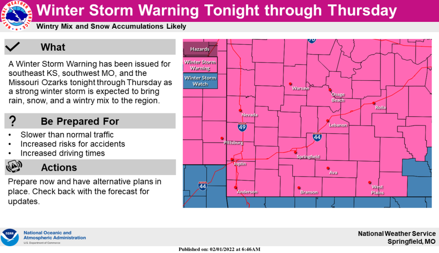
UPGRADED: WINTER STORM WARNING now in effect for the Four States

(KSNF/KODE) – A Winter Storm Warning has been issued for southwest Missouri and southeast Kansas.

National Weather Service Springfield, MO
  • Midnight Tuesday to midnight Thursday
  • Snow and sleet accumulations between 4 – 11 inches
  • Freezing rain accumulations around 1/4 inch

TIMING:

  • Tuesday afternoon: RAIN
  • Tuesday overnight to Wednesday: FREEZING RAIN
  • Wednesday: FREEZING RAIN/SLEET
  • Wednesday Night: SNOW
  • Thursday: SNOW

Northeast Oklahoma and northwest Arkansas remain under a WINTER STORM WATCH as of 8:30am Tuesday morning.

We encourage residents to keep a close eye on the forecast and remain calm as we continue to iron out this forecast.

Our mobile app for both iPhone and Android is a great resource to help you stay up to date with the latest forecast. Download it in your respective app store.

Biden approves Missouri's disaster declaration from Dec. 10 tornado

ST. LOUIS – President Joe Biden approved Missouri’s disaster declaration from the December 10 tornado that killed at least two people.

The White House said Biden gave his approval Monday and “ordered Federal assistance to supplement state and local recovery efforts in the areas affected by severe storms, straight-line winds, and tornadoes.”

The federal funding will be available to the state, local governments and private nonprofit organizations in order to repair or replace facilities in Bollinger, Dunklin, Iron, Madison, Pemiscot, Reynolds, and Wayne counties damaged by the storms. The funding is also available for “hazard mitigation measures.”

The Federal Emergency Management Agency and the Department of Homeland Security named DuWayne Tewes the Federal Coordinating Officer for Federal recovery operations in those areas.

Light snow & some travel impacts this morning; Bitterly cold today

Light snow is falling across the Four States this morning, with the higher totals and bigger travel impacts staying north of Jasper and Cherokee counties. Still, a dusting of snow (which is expected across most of SE Kansas and SW Missouri) could create issues on the roads this morning, so give yourself extra time and use caution out the door, and make sure to bundle up! Wind chills will be near zero through Thursday and even into Friday morning. We’ll see some sunshine this afternoon and into Friday. Stay updated with current road conditions through kandrive.org and modot.org.

We’re also watching a rain system to impact us late on Saturday into early Sunday morning, but temperatures should stay above freezing so that we would only see rain. Expect breezy conditions this weekend before we see calm and warm weather into the beginning of next week.