Eyeing possible winter weather next week in the Four States

(KSNF/KODE) — There’s a growing potential for winter weather to impact the Four State Region next week.

Meteorologists are eyeing late Tuesday into early Thursday next week for the storm system to move through the Joplin – Pittsburg areas.

There’s a lot still unknown, though.

  • Exact timing
  • Exact track of the storm system
  • Precipitation type (models hint at a mix of rain, snow, and ice, potentially)
  • Precipitation amounts
One possible model run for next week – this forecast WILL change.

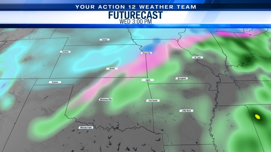
The jet stream in the upper levels of the atmosphere is expected to bring us a colder air mass from the north, and confidence is growing more and more that moisture from the Gulf of Mexico will also be present with this next storm system.

But, again, a lot of questions remain with this system.

We encourage residents to keep a close eye on the changing forecast, have back-up plans for any activities next week during this time frame just in case, and remain calm as we continue to iron out this forecast.

Our mobile app for both iPhone and Android is a great resource to help you stay up to date with the latest forecast. Download it in your respective app store.

Severe Weather Possible Sunday in the Four States

KSNF/KODE — A Slight Risk of severe weather is possible Sunday.

Timing is late Sunday night, after 8pm.

Severe Weather Possibility for Sunday, Oct 10th

Main threats:

– Large Hail

– Damaging Wind

– A small tornado risk also exists

Via Storm Prediction Center

Stay “Weather Aware” by downloading our mobile app for both iPhone and Android. You will get alerts should any storms turn dangerous.

Severe Thunderstorm Watch for a couple Four State Counties

(KSNF/KODE) – A Severe Thunderstorm Watch is in effect until 10pm for Bourbon (KS) and Vernon (MO) counties.

Risks with storms that will develop include:

  • Large, damaging hail
  • Damaging wind gusts
  • Frequent lightning

Storms will likely develop along a frontal boundary around 7:00pm.

Remember:

A WATCH: The atmosphere conditions are coming together and a severe storm could develop.

A WARNING: A severe storm has developed and is currently on the radar.

You can keep track of these storms using the Interactive Radar on our mobile app for both Android and Apple.

Friday Night Storms: Severe wind and hail are possible

(KSNF/KODE) – A “storm complex” situated in northeast Kansas and northwest Missouri as of Friday afternoon will take a deep dive south into Friday night.

This is a simulation of what the radar might look like around 9:00pm:

Recent models are trending less and less severe, but the chance still exists for this complex to move through our area.

If it holds together, the main threats are:

  • Strong damaging winds
  • Large, damaging hail
  • Winds could top 70 mph
  • Timing: 4pm – 10pm

The tornado threat is very low and should not be of too much concern.

The Storm Prediction Center has placed our area in either an Enhanced (orange) or Slight (yellow) risk of severe weather due to the severe probabilities.

This forecast will be monitored closely by local weather experts.

The general public is encouraged to pay close attention to any forecast changes, as well.

For updates, download our mobile app for both

Google Play and Apple

Preliminary report: First May on record with no EF-3 or stronger tornadoes

(KSNF/KODE) – The Storm Prediction Center has released some surprising new statistics in its May 2021 severe weather synopsis.

The most “remarkable” statistic shows the month was the first May on record with no tornadoes that were rated EF-3 or stronger.

That’s what preliminary data is showing, at least.

Record keeping began in 1950, so this is the first May since then, across the nation, that tornadoes were on the low-end of the Enhanced Fujita scale.

However, the month saw a quantity of tornadoes.

May 2021 had 289 tornadoes across the nation, which is slightly higher than the 2011-2020 yearly average of 272.

The full report can be found on the Storm Prediction Center‘s social media.

FREEZE WARNING and Watch in effect for Thursday morning

(KSNF/KODE) — Winter is not quite done with the Four State region just yet.

A FREEZE WARNING is in effect for the counties in PURPLE from 1:00am – 9:00am Thursday.

A FREEZE WATCH is in effect for the counties in LIGHT BLUE from late Wednesday night to early Thursday morning.

Temperatures as low as the upper 20’s are expected in the forecast area.

These low temperatures, as well as frost, will damage sensitive early-Spring plants.

The National Weather Service encourages you to take steps now to protect any blooming outside plants.

TORNADO WATCH issued for parts of the Four State region until 8pm Wednesday

(KSNF/KODE) — A Tornado Watch is in effect for counties in southwest Missouri, northeast Oklahoma, and northwest Arkansas.

A WATCH means atmospheric conditions are favorable for tornadoes to develop.

Remember, it takes many ingredients in the atmosphere to come together so a tornado is possible for the counties in RED.

Download our mobile app for both Apple and Google Play to get an alert when a severe storm is near you.

Stay weather aware this St. Patrick’s Day!