JOPLIN, Mo. (KSNF) – Anywhere from 1-4 inches is possible with incoming storms on Wednesday and Thursday.
Showers and storms are expected as early as late Wednesday morning, with a very small chance for severe storms in northeast Oklahoma under a SLIGHT risk.
The bulk of the severe weather will be in central Oklahoma down to northern Texas.
Severe storms are expected Thursday afternoon as well, but mainly to the cities east of us like Branson, Rolla, and West Plains.
Those places are under an ENHANCED RISK, will a swath of the Four State Region in southwest Missouri and southeast Kansas is under a SLIGHT risk.
JOPLIN, Mo. (KSNF) – Severe storms are trucking eastward through Oklahoma and Kansas as of 7:00pm Monday.
As the storms move east, they will start to lose a little steam. That means wind is our main threat in the Four State region.
Hail is a secondary threat, and it could be damaging.
As the storms congeal into a line segment, isolated tornadoes still can’t be ruled out.
These are usually quick, spin-up tornadoes on the edge of the line of storms.
We have received quite a bit of rainfall today, as well. A Flood Watch will be posted until Tuesday morning, as creeks and rivers may rise from 1-2 inches of additional rainfall.
We’re also paying attention to a second severe weather event later this week Wednesday night into Thursday morning.
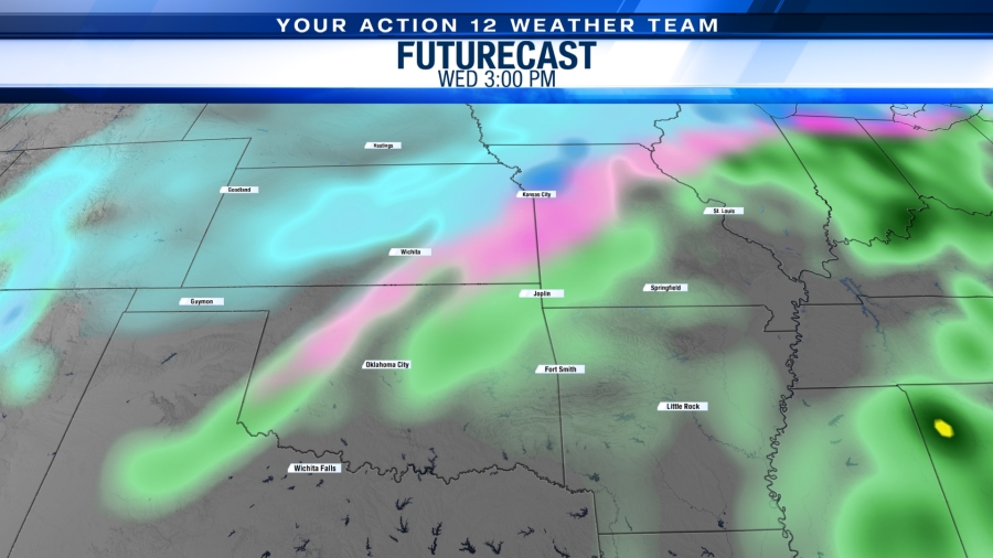
JOPLIN, Mo. (KSNF) – Wednesday night will bring storms with winter returning on Thursday.
A broad look at the Freeman Health First Alert Doppler radar shows all of the advisories, watches, and warnings, with several of them overlapping.
So, let’s break down each one for you.
WEDNESDAY AFTERNOON:
A WIND ADVISORY is in effect for the counties you see in blue below until 6:00pm Wednesday.
Winds are sustained around 25 miles per hour and gusting up to nearly 50 miles per hour in many spots.
The Joplin Regional Airport recorded a wind gust of 47 miles per hour between 1:00pm and 2:00pm.
WEDNESDAY NIGHT:
Storms are expected to form late tonight and move from west to east during the overnight hours.
There is a potential for heavy rainfall so an AREAL FLOOD WATCH has been issued for southwest Missouri counties in green.
Some storms could be low-end severe with wind and hail as the main threats, although the majority of severe weather will be south of our viewing area.
THURSDAY:
As the front moves across the area, rain will switch to a wintry mix and then full snow as the day goes on.
Winter Storm Warning in Pink – 3:00am – 9:00pm THURSDAY
Winter Weather Advisory in Purple – 9:00am – 9:00pm THURSDAY
There is a chance for a glaze of ice with this winter storm as it moves through.
Amounts are below and are approximate. Travel could be impacted with this system.
Snow accumulation looks to be a trace to 2 inches, possible. Higher amounts will be towards Nevada, MO and Fort Scott, KS, as well as some of our southeast Kansas counties like Labette, Montgomery, Woodson, Wilson, and Neosho counties.
We highly recommend downloading our mobile app for both Apple and Google Play so that you can stay up to date with the latest information.
JOPLIN, Mo. (KSNF) – We still anticipate a “mixed bag” of weather as our next weather system approaches from the west.
TUESDAY:
A Red Flag Warning is in effect until 7pm for much of southwest Missouri, southeast Kansas, and northeast Oklahoma.
Humidity values are below 30% and winds are gusting well over 25 miles per hour.
WEDNESDAY EVENING:
Storms are expected to form Wednesday afternoon and evening. As of Tuesday afternoon, the Storm Prediction Center has kept our region mainly in a MARGINAL RISK of severe storms.
A slightly higher risk of severe storms (SLIGHT RISK) is in the yellow to our southwest.
Because winds will gust to nearly 40 miles per hour BEFORE the storms, a WIND ADVISORY is in effect until 3pm on Wednesday.
Winds could be damaging even without storms in the area.
Some spotty showers may form as early 3pm on Wednesday, but are more organized structure of storms is expected late Wednesday night.
THURSDAY MORNING:
Then, through the overnight hours, a line segment of storms forms and moves through in the early morning hours of Thursday. Temperatures still will not drop far enough, so we are anticipating rain and storms for that line that moves through at that time.
Main risks would be:
Damaging wind gusts
Damaging hail
Due to an excessive amount of rainfall expected, we have an Areal Flood Watch in effect for our southwest Missouri counties.
THURSDAY AFTERNOON:
As the storm system moves from west to east, temperatures drop off and snowfall is then expected Thursday through the daytime hours.
The system finally exits our region by Thursday night.
As of Tuesday afternoon, we are NOT under any sort of winter storm watches or warnings, though.
It is unclear just how impactful the wintry weather will be, but if we get a lot of snowfall, we could see a trace to 2 inches in our area.
A glaze of ice is also possible with the incoming system.
THIS IS A CONSTANTLY CHANGING FORECAST:
Each model run, with each hour, continues to show bobbles in the path of the storm and differences in just how it will affect our region.
We highly recommend downloading our mobile app for both Apple and Google Play so that you can stay up to date with the latest information.
(KSNF/KODE) — There’s a growing potential for winter weather to impact the Four State Region next week.
Meteorologists are eyeing late Tuesday into early Thursday next week for the storm system to move through the Joplin – Pittsburg areas.
There’s a lot still unknown, though.
Exact timing
Exact track of the storm system
Precipitation type (models hint at a mix of rain, snow, and ice, potentially)
Precipitation amounts
One possible model run for next week – this forecast WILL change.
The jet stream in the upper levels of the atmosphere is expected to bring us a colder air mass from the north, and confidence is growing more and more that moisture from the Gulf of Mexico will also be present with this next storm system.
But, again, a lot of questions remain with this system.
We encourage residents to keep a close eye on the changing forecast, have back-up plans for any activities next week during this time frame just in case, and remain calm as we continue to iron out this forecast.
Our mobile app for both iPhone and Android is a great resource to help you stay up to date with the latest forecast. Download it in your respective app store.
(KSNF/KODE) – A “storm complex” situated in northeast Kansas and northwest Missouri as of Friday afternoon will take a deep dive south into Friday night.
This is a simulation of what the radar might look like around 9:00pm:
Recent models are trending less and less severe, but the chance still exists for this complex to move through our area.
If it holds together, the main threats are:
Strong damaging winds
Large, damaging hail
Winds could top 70 mph
Timing: 4pm – 10pm
The tornado threat is very low and should not be of too much concern.
The Storm Prediction Center has placed our area in either an Enhanced (orange) or Slight (yellow) risk of severe weather due to the severe probabilities.
This forecast will be monitored closely by local weather experts.
The general public is encouraged to pay close attention to any forecast changes, as well.