Warm and windy through tomorrow; Rain likely Wednesday night

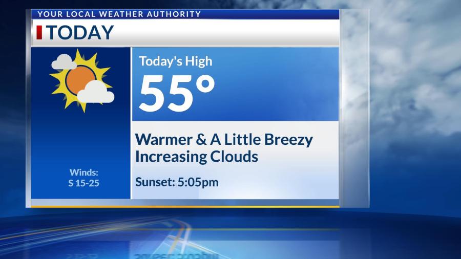
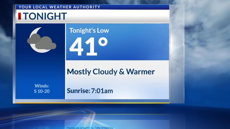
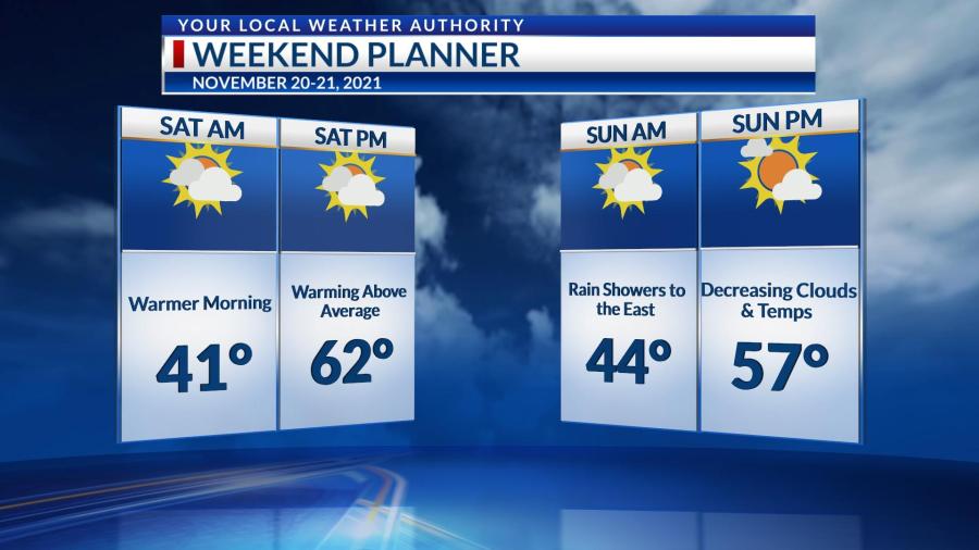
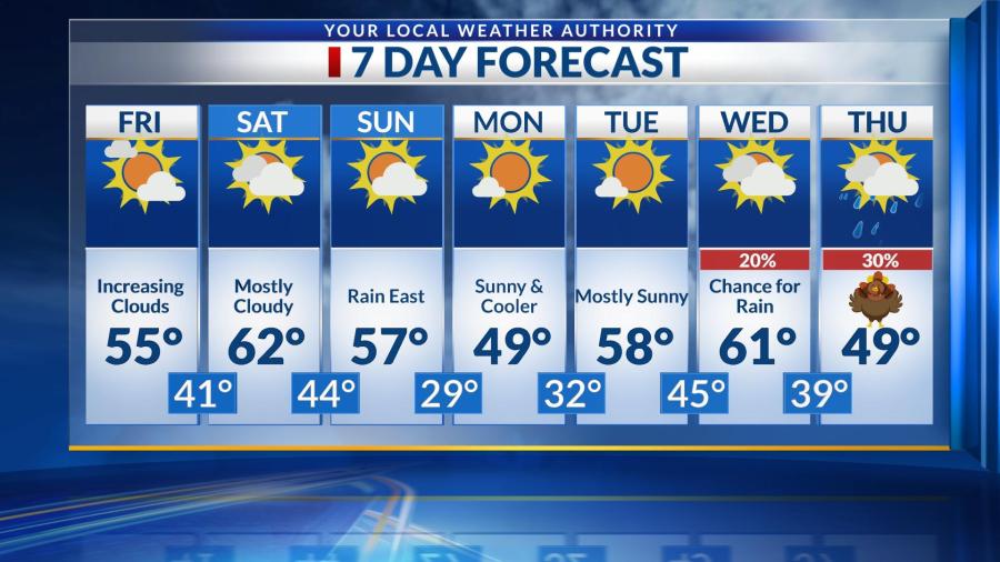
We’ll see sunshine and southerly winds pick up through your Tuesday, allowing for temperatures to warm into the middle 60s this afternoon. Both clouds and winds will increase overnight, as we’ll only cool into the upper 40s by tomorrow morning. Winds could gust up to 35 MPH through Wednesday before a cold front brings rain after sunset tomorrow. These showers could also have a few rumbles of thunder that will stick with us on-and-off through early Thursday morning. Rain should be done by sunrise Thursday morning, but Thanksgiving will be much cooler across the Four States. We should warm a little above average again as we head toward the weekend.

Week starts sunny, Wednesday night showers possible

Mostly sunny skies are expected for Monday and Tuesday, with low relative humidities leading to elevated fire danger Tuesday.

A cold front will bring a chance for rain Wednesday night, but this precipitation should clear out for Thanksgiving Day.

Expect Thursday to be cooler, with highs in the mid to upper-40s.

We’ll start to warm up a bit with a return to sunshine for Friday into the weekend.

The 8-14 Day Outlook from the Climate Prediction Center calls for a good chance of above normal temperatures to end November and begin December.

Have a great week!

Calm today, Warm and breezy tomorrow before Wednesday night rain

Your Monday in the Four States will be calm and fall-like with mostly sunny skies. Southerly winds will gust up to 30-35 MPH through Tuesday and Wednesday, allowing temperatures to warm into the middle 60s. This will be ahead of a cold front set to bring us rain overnight Wednesday into early Thursday morning. Rain totals will be closer to a half inch Wednesday night. Thanksgiving looks to be dry once the sun comes up, but temperatures will only warm into the middle to upper 40s. We should see dry and more average temperatures heading into next weekend.

A few sprinkles possible tonight; dry and cool for Thanksgiving

A cold front may touch off a few showers and sprinkles tonight into Sunday morning, but most areas will remain dry. Highs Sunday will be in the upper-50s.

Expect slightly cooler conditions for Monday, before we warm back into the lower-60s Tuesday.

Another cold front will approach the area Wednesday, with any rain expected to occur overnight Wednesday night, leading to a dry and cool Thanksgiving, with highs in the upper-40s.

Partly to mostly sunny skies are then expected for Friday and Saturday, with highs in the low to mid-50s.

Have a great Sunday!

Warming through Saturday; Cooler by early next week

Temperatures are in the 20s to begin your Friday, but we’ll warm into the middle 50s this afternoon with a few more clouds in the sky. We’ll only cool into the lower 40s overnight before seeing highs in the lower 60s tomorrow. A cold front will approach us on Sunday morning, and we could see just a few sprinkles before sunrise. The rain will stay primarily to our east. However, this system will cool us into the upper 40s as we begin next week.

We’re also monitoring another cold front that could impact us late Wednesday and into Thursday. This would bring us some rain and cooler temperatures for Thanksgiving. We’ll keep you updated as the holiday gets closer.

Drying out, windy Thursday and Friday

After the last of the showers and thunderstorms move out of the area late this evening, mostly sunny skies are anticipated through Saturday.

It will become rather windy for Thursday and Friday, with gusts up to 30 mph possible.

Highs around 60 Thursday will drop to the lower-50s for Friday and Saturday.

A warming trend is expected starting Sunday, and we’ll eventually reach the upper-60s by Tuesday and Wednesday.

Have a great rest of your week!

Still warm Monday, cooler pattern returning soon

It will remain mostly sunny and breezy Monday, with mild high temperatures in the lower-70s.

We’ll cool down a bit for Tuesday and Wednesday, with highs in the mid to upper-60s.

A few showers and thunderstorms will be possible Wednesday afternoon, with more widespread precipitation holding off until Wednesday night.

After a cold front moves through, our highs will be knocked down to the mid to upper-50s for Thursday, and upper-40s for Friday into Saturday.

The 8-14 Day Outlook (November 15-November 21) from the Climate Prediction Center calls for below normal temperatures to continue.

Have a great Monday!

Staying dry and warm into Tuesday, another late week cooldown

Mostly sunny skies will remain in the forecast for Sunday and Monday, with highs in the mid to upper-60s.

A small chance of a shower will exist north of I-44 Tuesday afternoon into Tuesday night, but most locations will remain dry.

Showers and thunderstorms will become increasingly likely Wednesday ahead of a strong cold front that will knock us back to the mid-40s Friday.

We could see some areas of drizzle (or even a snowflake or two) Friday before sunshine returns Saturday, with highs climbing back toward the 50 degree mark.

Have a great Sunday!

Widespread frost, possible freeze late week

Dry conditions are expected for much of Monday, with a small chance of a shower in the afternoon. Most locations will stay dry until at least sunset, with chances for rain continuing to increase through Tuesday and Wednesday.

Highs for Monday through Wednesday will be 15-20 degrees below normal — only in the mid to upper-40s.

Rain clears out by Thursday morning, but a frost (and possible freeze) can be expected Thursday, Friday and Saturday mornings.

We’ll start moderating the temperatures once again by next weekend, eventually reaching the upper-50s.

Have a great Monday!